

“If you are not willing to risk it all, then you have already failed.” Adventurers understand the risk. We understood the risk. Here is our story:
With over two years of planning, multiple test runs, rider assignments and practice days, judgement day had arrived. The plan was to jet ski from Boynton Beach, Florida to Port Lucaya on Grand Bahama Island – thus creating what we called the “North Bahamas Jet Ski Loop.”
On the day of departure, we had a PWC ride team of seven skis, including what we believed to be the first solo female rider, Linda Cobelo, to cross the Gulfstream from Florida to Grand Bahama Island; our support boat captained by Leslee Tull Baute carrying significant others, children and gear. We were also joined by Captain Douglas Montgomery and family for the expedition after learning about it on the boating forum, The Hull Truth. The reality to risk-takers is never trust the weather, always expect the unexpected, prepare for the worst, and pray for the best.
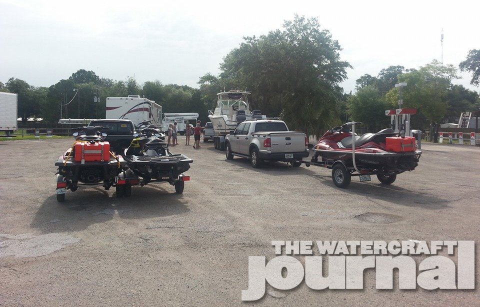
As the 18 of us stood staring out across the Intra Coastal Waterway, we could feel the wind – much more wind then forecasted – but no one was swaying. The final call was given and we shoved off.
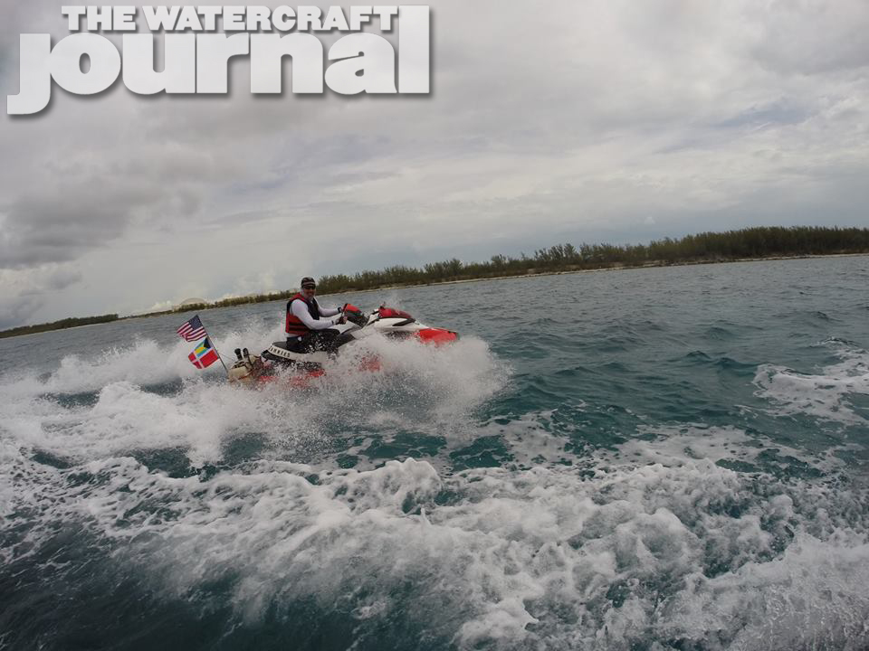
It was a calm dawn in the Intra Coastal Waterways, however, once passing the Boynton Beach Inlet we were immediately met with large seas and small intervals. Hoping this was just the typical demeanor of the jetty we pressed on East to find the waters growing in conditions. This went against every weather report and surf report we were studying.
The first six miles were brutal with no real way to explain it. From my experience, I could sense the wind was direct from the East at no less than 20mph. Combining that with shallow waters off the Florida Coast just intensified the surf. It was impossible to estimate the wave height but the back-to-back intervals directly in your face were an immediate challenge.
At the six mile mark, we were introduced to our first equipment failure, Michael Baute’s auxillary fuel system came off and fell into the water. His system, like ours, was hard-mounted with welded brackets and it only took six miles of Atlantic Ocean before it was ripped off the ski. The system was unrepairable on the water, but luckily for Mike, he was riding the FX HO which is a very fuel friendly machine to begin with so we pressed on.
The next 14 miles brought us deeper into the Atlantic, now dipping our toes in the Gulfstream and increasingly rougher conditions. Rider Andy Hodgen realized his fuel is not transferring. Andy, riding an Sea-Doo RXP 215 with the smallest stock fuel tank of all the skis (and not very fuel friendly) looked over the system but decided to push on further before attempting a mid-water fuel fill. At this point the crew on both boats were already sick and even a few of the jet skiers were as well. No amount of Dramamine was helping on this day. As we pushed on trying to reach our halfway point, Ken Roseman, riding his FX SHO and myself, riding the Kawasaki Ultra 310LX, both lost our SPOT emergency transponders into the ocean while other riders’ equipment, such as VHF and GPS had failed.
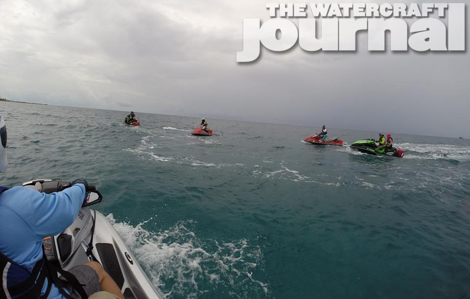
Now this is all new equipment, all of which had been tested for many rides before, so whether that was a coincidence or the curse of the Bermuda Triangle, we will never know. Finally reaching 35 miles after an exhausting 3 hours and 20 minutes, Andy made the call to literally wire in a new fuel pump on the water. Vince Cobelo’s job on this expedition was ride preparedness and true to his responsibility, Vince had all the spare parts needed, additional fuel pump and supplies setup in case of this or other scenarios. After a painstakingly long time, Andy accomplished the task, his fuel was pumping and we were back to the grind.
As luck would have it, as we exited the Gulf Stream moving closer towards our destination, the waters finally began to calm down. The pattern I’ve always noticed while studying the weather reports for both Florida Coast and the Grand Bahama Coast is a minimum 5mph increase wind and slight direction change. This day it was backwards. The wind decreased and direction shifted the closer we got to the island. Nearly seven hours post departure and nearly 69 miles later, we arrived in West End, Grand Bahama to refuel, clear Customs & Immigration, and grab a quick snack before continuing on the next 60 miles to the Flamingo Bay Resort & Marina in Port Lucaya.

Since the waters were rough and the wind blowing against the island from the southeast, the planned route of traversing the North Sound to the Lucayan Waterway was all agreeable; however, the North Sound is a very tricky boating area. There is an actual path to travel which we had mapped out but is nowhere near land. The boat was setup to run in no less than 10′ of water at low mean tide, based on the nautical maps uploaded to the lowrence GPS system. The Channel to the average person would seem ridiculously far offshore but that is something the Bahamas is known for, long even shallow ocean floor for miles.
Not wanting to risk hitting a rock or other obstruction under the surface of the water, the channel was and is the safest bet to traverse the North Sound. We made our way across the Sound and into the Lucayan Waterway. The Lucayan Waterway is the only man-made canal that runs north-to-south through the island. It is not well maintained but easily passable by large boats and a heck of a lot of fun for PWCs! Lining the shores we found thousands of conchs left behind by conch fisherman, thousands of beautiful shells just sitting there for the taking. The Lucayan Waterway dumps out into the tongue of the ocean and just east of Port Lucaya.

After a total of 127 miles, 10 hours and 10 minutes, we finally arrived at our destination, the Flamingo Bay Resort and Marina. Great place, amazing people, very helpful and friendly. Terrance, our Dockmaster jumped down to help unload the boat and skis and even allowed us use of their jet ski rental docks to make needed equipment inspections and repairs. The resort boasts a lagoon style pool with bar grotto, beautiful Taino Beach, nice restaurant and amazingly affordable rooms looking out over the Marina with 24/7 security.
After settling in, we hit the pool bellying up to the Grotto for a few much needed beverages then onto dinner on the beach overlooking the Atlantic Ocean. We received the post report of the ocean conditions and to our astonishment stated average wave conditions were between 9–to-12 feet with some larger rogue waves. Seeing a 32-foot boat’s stem and stern in the same frame from the rear of it nearly vertical makes you a believer in what type of conditions we battled through.
The adventure did not end there! Please be on the lookout for Part 2, 169-plus-miles in one day to the Abacos Islands and back!


9 – 12 feet? Sorry, I’ve made the crossing in 5 – 8’s in a 55 Viking. There is no way you would have made it in 9 – 12’s. Just saying … (I don’t even see white caps in the video).
Kudos to those putting it together. THT is also a great site. Looks like a fun trip, I hope to try it sometime in my 14 fx ho.
It was HUGE that day going over… We never said wave height, we just eluded to post surf report & what it said…
https://www.google.com/maps/d/edit?hl=en&authuser=0&mid=zCp78oyeEIrs.kMvtIsNTo9PA
It took us 6:40 to get to the West End and a total of more then 10:45 to Freeport… NOT because we chose to go an AVERAGE of 14mph… You can click on the “END” of the TRACKS and see the stats of the day there… Going back to Boynton Beach from Freeport took us just over 4 hrs. MUCH flatter ride home.
Anyway, it was a GREAT trip and would do it again (IN BETTER CONDITIONS)…
I doubt it myself…and I was there. I’m 6’2″ and I can only say that throughout the middle of the crossing at the bottom of the trough I could see no one…I could only see the next wave 2-3′ higher than my head as I was standing (I don’t sit until I have to going through the wave).
Sadly those on the boat were under such duress they could take no video. On the skis, forget about it because everything failed or was ripped from the ski or our bodies with few exceptions including the SPOT that recorded the trip.
Are we liars exaggerating the conditions of the trip? No. We read about the sea conditions once we reached our destination and had our wits back enough to look it up. There is no way you can go through that and realize what it really is or you would be too terrified to continue on or turn back.
[…] 10 hour, 127-mile open ocean ride from Boynton Beach, Florida to Grand Lucaya, Grand Bahama Island. You can read about that here. Three days later, seven jet skis and 10 riders, which included our female solo rider, Linda Cobelo […]
Were your Spots attached to you? Your skis? Why not keep them in storage?
We are going all the way to Abacos this June. 8 of us total. This article has made me very nervous now.
That wasn’t clear. I meant, were the SPOTS attached to you or to your skis? Why didn’t you keep the SPOTS in a storage compartment or bag on your ski?
Why go north from West End and then cut through the island to get to Freeport? Why not just head southeast along coast (far enough out to stay deep) and get to your hotel?